JAPAN
Jiu-Jitsu
Climate in Japana aries from tropical in south to cool temperate in north. "The weather in Japan is mostly temperate, with four distinct seasons. Winters are cool and sunny in the south, cold and sunny around Tokyo (which occasionally has snow), and very cold around Hokkaido, which is covered in snow for up to four months a year. The Japan Sea coastline also often receives heavy snowfall during winter.
Summer, between June and September, ranges from warm to very hot with high levels of humidity in many areas. Typhoons, or tropical cyclones, with strong winds and torrential rains often hit Japan during August and September, but can occur through May to October. Strong typhoons often affect transport systems, causing rail and air services to be stopped, and there is a danger of landslides in rural areas.
Spring and autumn are generally mild throughout the country, and offer spectacular views of pretty sakura cherry blossoms and colorful autumnal leaves, respectively. Rain falls all over Japan throughout the year but June and early July is the main rainy season. Umbrellas are a daily essential during this season. Hokkaido, however, is generally much drier than the Tokyo area."
Geography, Maps, and Weather
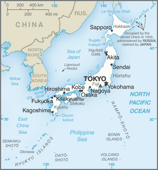
Japan is located in Eastern Asia, island chain between the North Pacific Ocean and the Sea of Japan, east of the Korean Peninsula.

" Total Area: 377,915 sq km
country comparison to the world: 62
land: 364,485 sq km
water: 13,430 sq km
Coastline: 29,751 km
Terrain:mostly rugged and mountainous
Elevation extremes:
lowest point: Hachiro-gata -4 m
highest point: Fujiyama 3,776 m
Natural resources:
negligible mineral resources, fish
note: with virtually no energy natural resources, Japan is the world's largest importer of coal and liquefied natural gas, as well as the second largest importer of oil
Land use:
arable land: 11.26%
permanent crops: 0.81%
other: 87.93% (2011)
Irrigated land: 25,000 sq km (2010)
Total renewable water resources: 430 cu km (2011)
Freshwater withdrawal (domestic/industrial/agricultural):
total: 90.04 cu km/yr (20%/18%/62%)
per capita: 714.3 cu m/yr (2007) "
Slightly smaller than California
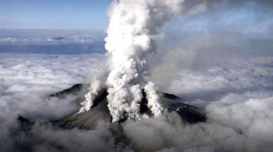
"Natural hazards: many dormant and some active volcanoes; about 1,500 seismic occurrences (mostly tremors but occasional severe earthquakes) every year; tsunamis; typhoons
volcanism: both Unzen (elev. 1,500 m) and Sakura-jima (elev. 1,117 m), which lies near the densely populated city of Kagoshima, have been deemed Decade Volcanoes by the International Association of Volcanology and Chemistry of the Earth's Interior, worthy of study due to their explosive history and close proximity to human populations; other notable historically active volcanoes include Asama, Honshu Island's most active volcano, Aso, Bandai, Fuji, Iwo-Jima, Kikai, Kirishima, Komaga-take, Oshima, Suwanosejima, Tokachi, Yake-dake, and Usu."
Weather